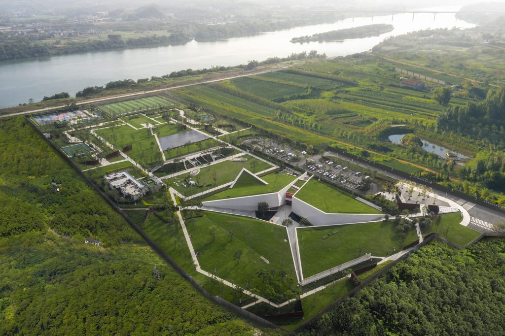
这个自然公园的前身是一个垃圾填埋场。垃圾填埋场的历史可以追溯到1974年,主要处理巴塞罗那都市圈的垃圾,关闭之时,已经填埋了85公顷的范围,填补了山谷的三分之二高度。修复前,最上层的垃圾就这么暴露着,和山谷的自然风景形成鲜明对比。

修复工程从三个基本层面着手:1,解决复杂的技术问题,2创建一个新的公共空间,3创造一个新景观。集合多学科(环境工程,地质,景观建筑学,园艺学)的技术力量,让这个地方的新生。先从技术层面制定出合理的工作策略。根据垃圾填埋场的几何形状确定出需要稳定和防护的区域,然后布置管道收集沼气,并排除产生的渗透液。将垃圾填埋场做成意大利式的台地式园林,就像梯田一样,并能成为一个公共空间,一个都市自然公园,同时允许车行和人行多种道路。这里离人口聚集地不远,场地最后可以拥有道路和停车场是至关重要的。因为被修复后的场地的形态和原始条件差距太大,所以在景观处理上,采用了农业耕地景观。农业景观可以很好的适应修复性的受损场地,是最合理也是最有效的方式。现在这里已经被转变成一个农业景观场所。地形处理是最基本的要素,布置的提防工程和渠道可以保证新地形的稳固,在此基础上布置了养殖梯田,树木种植区,作物种植区。雨水径流被引入雨水蓄水池。同时用沼气产生的动能驱动灌溉系统。最后,景观建筑师为场地补植了低维护的,耐旱乡土植物。植物有:荆棘,灌木,树木。以在林间间种豆科植物,促进网站生态系统的维持。这样作物田随着时间的推移,会变得更巩固,或许在遥远的将来,这里会完全的融入自然公园以及周围的景观。这背后的意义,不仅仅是对景观的追求,也向人们展示了新社会对待环境应有的态度。这里也开设了信息中心,同时占据最好的位置,可以让游客查看恢复工作。这个默默为人类服务几十年的地段,重新进入公众视野后,它的历史不应被忘却。
Landscape restoration of the Vall d’en Joan landfill siteGarraf, Barcelona
Architects: Enric Batlle, Joan Roig, architects, Teresa Galí, agricultural engineer Collaborators:
PROSER, Proyectos y Servicios, SA, GEOCISA, RDS, Jordi Nebot, Xavier Ramoneda,
Mario Su?er, architects, Elena Mostazo,
agricultural engineer Design date: 2002
Construction date: 2003-2010
Client: AMB, Entitat Metropolitana de Serveis Hidràulics i Tractament de Residus,
Diputació de Barcelona Contractor: URBASER, FCC, CESPA, COMSA,
EMTE Area: 85 Ha
Photographs: Eva Serrats, Jordi Puig
The Vall d’en Joan is situated in the Natural Park of Garraf, in the municipalities of Begues and Gavà, in the county of Baix Llobregat. Originally, this spot was one of the many closed, winding valleys that form the foothills of the Garraf massif. Its use as a landfill dates back to 1974, since when it has been the destination of most of the urban waste produced by Barcelona and its metropolitan area. When closure of the site began, it occupied an approximate extension of 85 hectares and had been filled to two-thirds of its original level.
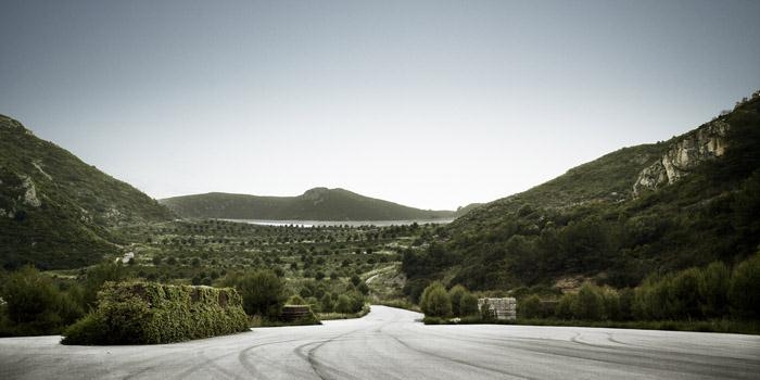
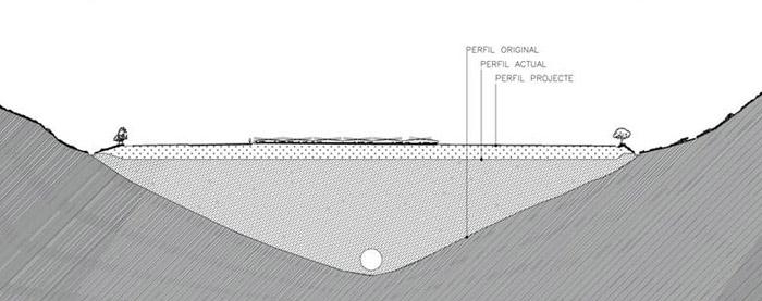
Before restoration, the landfill was a vast extent of steep slopes where a layer of 20 centimetres of earth covered the waste beneath, but with no definitive capping. This huge sloping tract covered the entire valley, the top part of which was still functioning as a landfill. The image of the valley occupied by the dump contrasted with the variety of relief and vegetation of the landscapes in the natural park in which it was set.
The landfill restoration project aimed to use a single operation to address the three basic aspects identified: solving a complex technical problem, creating a new public space and constructing a new landscape. The multidisciplinary technical team that carried out restoration brought to this single intervention knowledge from different disciplines (environmental engineering, geology, landscape architecture and agronomy) to create this new place.
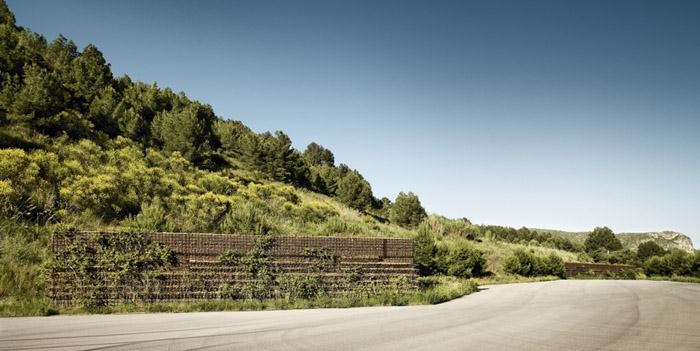
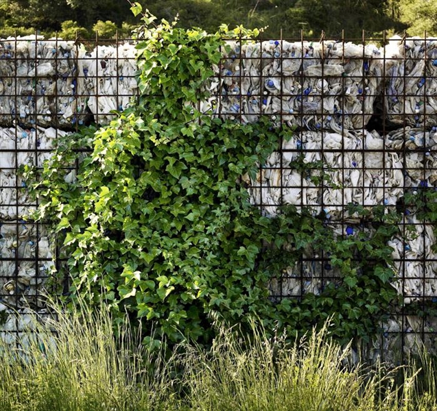
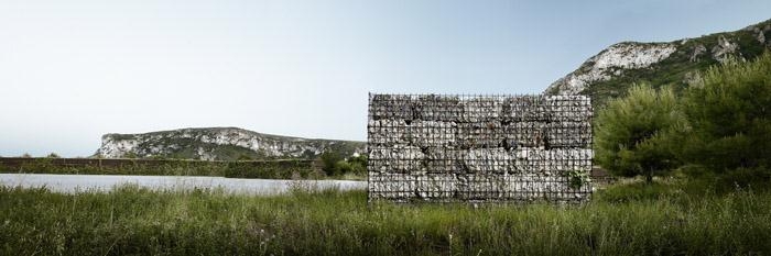
The complex technical problems that derived from closing and capping the landfill served to outline a working strategy based on rationalization. The organization of stabilizing terraces and retaining embankments, and the track providing access marked out the geometry of the landfill, and structured the layout of piping to collect and conduct biogas to the transformation plant where it is turned into electrical energy and the draining and storage of leachates. This organization is complemented by the construction of channels to divert runoff.
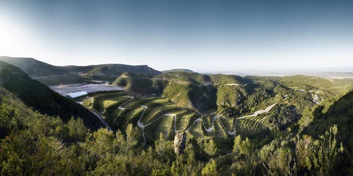
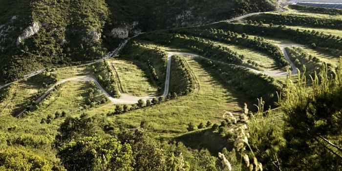
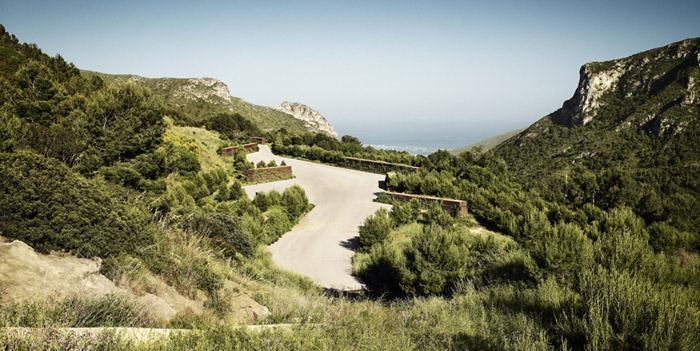
The technical process of capping structured the place as a rising itinerary between terraces and banks. Its similarity to the layout of cultivated terraces, like Italian gardens on hillsides, comprising plots of different levels, showed the way to turn it into a public space that could be used as a park without actually being one in typological terms. It might be described as a Metropolitan Park, due to its size, its proximity to various centres of population, and the fact that it is anchored in a practically rural geographical setting, Garraf Natural Park, for which it acts as a gateway thanks to its connection with the GR long-distance walks. This fact determined a use and a functioning associated with vehicles (private and public) and a diversified organization of routes which, in this case, clearly coincides both with the routes created for the landfill and those included in the technical project for capping. In this context, the
road to the site and the car park acquire particular importance.
Of the three original objectives, the third, to construct a new landscape, was influenced by a particular desire to integrate the former landfill into Garraf Natural Park. Obviously, the then morphology of the site was completely different to its original state. However, in other places in Garraf there are cultivated valleys that have been modified
by agricultural techniques adapted to the geography, with systems of terrace construction, drainage and farming that were very similar to the technical needs involved in closing and capping the landfill. Yet it was not just this similarity that attracted us; it was also the conviction that the use of agricultural systems was by far the most effective and logical way of intervening in the restoration of damaged landscapes, thanks to their capacity to provide guidelines for organization, maintenance and continuance.
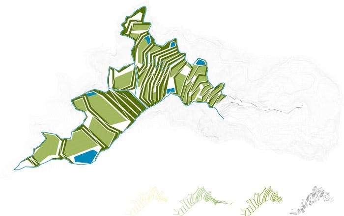
This conversion of a landfill into a farming landscape was based on three key factors: topography, hydraulics and vegetation. The topographic system was addressed by the capping project. Whereas the project for closure of the landfill involved channels and embankments, the landscape restoration project had recourse to farmed terraces,
tree-planted plots and fields of crops.
The hydraulic requirements for the implantation of the new landscape had to be addressed in the project. The various drainage systems existing on the series of terraces were used for this purpose, channelling rainwater to cisterns that we inserted in the banks of the landfill, and the irrigation system was run on the energy produced by the transformation of biogas.
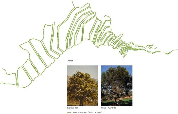
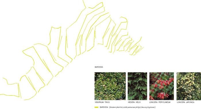
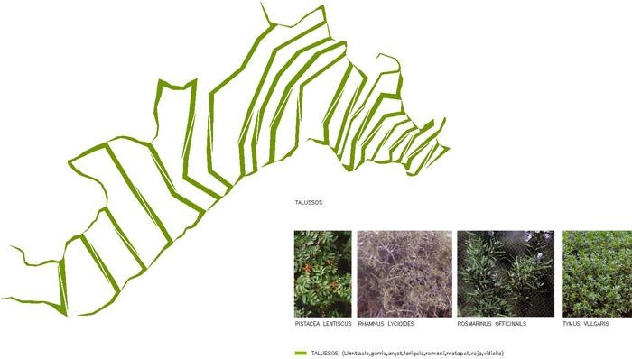
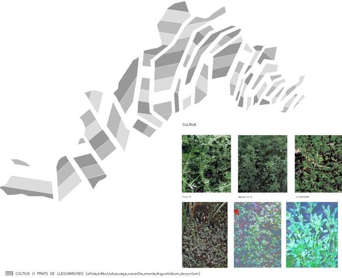
Finally, for the replanting of the site we used resistant native species that require little water and are adapted to the environment. The vegetation introduced includes a range of bramble, scrub and Mediterranean maquis, trees and shrubs, and nativeleguminous crops in reference to the surrounding mosaic of farmland and woods, promoting the succession of the primary ecosystems on the site, which will, in time, develop and adapt to the environment. The crops envisaged for the series of terraces should also evolve with time to adapt fully to the site. The terraces will be cultivated for a period of time until the slopes are consolidated, then the crops will be allowed to evolve towards the surrounding landscapes with the ultimate aim in the distant future of full reintegration into Garraf Natural Park.
The driving force behind this restoration was not just reintegration into the landscape. The operation also served to showcase new attitudes that society should adopt towards the environment. To this end, public access to the restored area was created, with an information centre explaining the work carried out and projects under way. The approach road constitutes a door to this new landscape, leading to vantage points from which visitors can view restoration work and a track that winds its way over the terraces. Walls of waste matter and earth guide the path to this new place, reminding us of its origins, the role it played for decades and how it has recently been salvaged for public use.
项目来源: Batlle i Roig Arquitectes